
Georgina’s guidebook
Beaches
Elly Bay is one of two local area Blue Flag beaches and is one of the 11 Blue Flag beaches in Mayo. It has consistently retained its Blue Flag status for a number of years.
It is about 20mins drive from the house and there are two beaches divided by the main road towards Blacksod.
The east side of Elly Bay is calm and sheltered and is considered an ideal spot for swimming. The beach has beautiful soft sand and the water is crystal clear.
There are parking and toilet facilities in front of the entrance to the beach as well as picnic benches.
9 locals raden deze aan
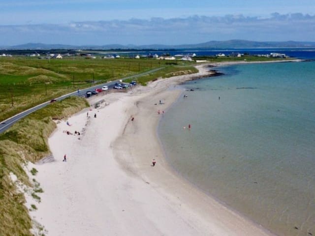
Elly Bay Beach
Elly Bay is one of two local area Blue Flag beaches and is one of the 11 Blue Flag beaches in Mayo. It has consistently retained its Blue Flag status for a number of years.
It is about 20mins drive from the house and there are two beaches divided by the main road towards Blacksod.
The east side of Elly Bay is calm and sheltered and is considered an ideal spot for swimming. The beach has beautiful soft sand and the water is crystal clear.
There are parking and toilet facilities in front of the entrance to the beach as well as picnic benches.
Mullaghroe is our other local area Blue Flag Beach of the 11 Blue Flag beaches in Mayo and it has also consistently retained its Blue Flag status for a number of years.
It is located about 25mins drive from the house past Elly Bay towards Blacksod. From the R313 a single-track road leads down to the beach. There is a small car park with one picnic bench and toilet facilities and from the car park a sandy path (not suitable for wheelchair access) leads to the beach.
The sand is soft and pale and the water is crystal clear making it a very pleasant spot to swim.
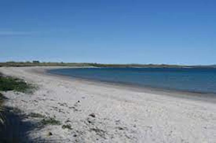
Mullaghroe
Mullaghroe is our other local area Blue Flag Beach of the 11 Blue Flag beaches in Mayo and it has also consistently retained its Blue Flag status for a number of years.
It is located about 25mins drive from the house past Elly Bay towards Blacksod. From the R313 a single-track road leads down to the beach. There is a small car park with one picnic bench and toilet facilities and from the car park a sandy path (not suitable for wheelchair access) leads to the beach.
The sand is soft and pale and the water is crystal clear making it a very pleasant spot to swim.
Tarmon beach is a Green Coast awarded beach.
The beach is located along the main road (R313) to Blacksod just after the village of Aughleam (Eachléim); about a 30min drive from the house.
It is a sheltered bay on the East side of the Peninsula and has soft white sand and crystal clear waters.
There are parking and toilet facilities in front of the entrance to the beach (which is accessed by steps down to it) and there are two picnic benches. It’s a fabulous spot for a picnic.
This beach is one of our personal favourites!!
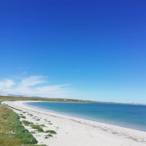
Tarmon
Tarmon beach is a Green Coast awarded beach.
The beach is located along the main road (R313) to Blacksod just after the village of Aughleam (Eachléim); about a 30min drive from the house.
It is a sheltered bay on the East side of the Peninsula and has soft white sand and crystal clear waters.
There are parking and toilet facilities in front of the entrance to the beach (which is accessed by steps down to it) and there are two picnic benches. It’s a fabulous spot for a picnic.
This beach is one of our personal favourites!!
Walks / Hikes
A spectacular walk that can be completed in under 2 hours, the Erris Head Loop Walk winds around the headland of, yep, you’ve guessed it, Erris Head!
At approx. 5km, it’s not an overly challenging walk, but the weather plays a big part, and you need hiking boots to traverse the boggy areas. If you want to stop for a picnic, there’s a point about halfway where you can see Eagle Island and its lighthouse. Quite a lot of the walk is uphill, but it’s gradual, and the higher you climb, the more spectacular the views.
The Erris Head Loop Walk mainly follows an old earth bank around the headland, with a couple of stiles and a footbridge to cross along the way.
At the top of the loop, which is the tip of Erris Head, you can stop to take in the dramatic views of the North Atlantic with its rugged islands and remarkable sea arches.
This is a nice and easy walk that’ll treat you to stunning views and the kind of wild, unspoiled scenery that you’ll only find along the North Mayo coast.
There are parking and toilet facilities at the start/end of the loop as well as a coffee cart (weekends and summer only). As there are no fences along cliff edges along the the walk children should be supervised at all times.
15 locals raden deze aan
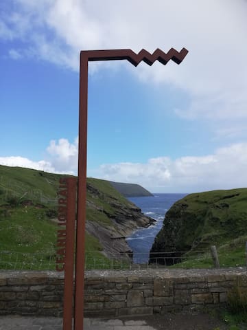
Erris Head Loop Walk
A spectacular walk that can be completed in under 2 hours, the Erris Head Loop Walk winds around the headland of, yep, you’ve guessed it, Erris Head!
At approx. 5km, it’s not an overly challenging walk, but the weather plays a big part, and you need hiking boots to traverse the boggy areas. If you want to stop for a picnic, there’s a point about halfway where you can see Eagle Island and its lighthouse. Quite a lot of the walk is uphill, but it’s gradual, and the higher you climb, the more spectacular the views.
The Erris Head Loop Walk mainly follows an old earth bank around the headland, with a couple of stiles and a footbridge to cross along the way.
At the top of the loop, which is the tip of Erris Head, you can stop to take in the dramatic views of the North Atlantic with its rugged islands and remarkable sea arches.
This is a nice and easy walk that’ll treat you to stunning views and the kind of wild, unspoiled scenery that you’ll only find along the North Mayo coast.
There are parking and toilet facilities at the start/end of the loop as well as a coffee cart (weekends and summer only). As there are no fences along cliff edges along the the walk children should be supervised at all times.
Golf
Carne Golf Links lies on the remote and rugged Mullet Peninsula, along the Wild Atlantic Way, in the North West of County Mayo, an area renowned for its’ wild and ancient landscape. Set in magnificent, unspoilt sand dunes stretching 150m above sea level, with breath-taking views of the Atlantic across Blacksod Bay and the legendary islands of Inis Glóire and Inis Géidhe.
The course features eighteen amazing holes designed by the late Eddie Hackett, and true to his philosophy for respecting the natural landscape, the tees and greens occurred naturally and very little earth moving was involved in the course construction. Carne was the last course designed by Hackett and many say it is his most challenging. When Eddie was designing Carne he always said that the most dramatic part of the dunescape at Carne should be developed into another course. Sadly, he did not live to see his vision realised.
It was 2013 before a further nine holes were opened on land described by Eddie Hackett as the most dramatic part of the dunescape at Carne. The Kilmore Nine, designed by Jim Engh and Ally McIntosh, was developed in line with Hackett’s ethos of respect for the natural landscape, and they integrate seamlessly with the original Hackett course.
The development of the new nine holes at Carne led to the creation of the Wild Atlantic Dunes course, which integrates the front nine holes of the Hackett 18 with the newer Kilmore Nine course.
It is arguably the most spectacular links course in Ireland, raw and untamed, with increased drama as the holes weave their way through the awe inspiring corners of the biggest dune system in the world.
The development of the Wild Atlantic Dunes course now gives us two courses at Carne – the original Hackett 18, and the newer Wild Atlantic Dunes 18 – the courses are in play on every second day.
Carne offers traditional raw links golf at it’s very best in a truly unique and idyllic golfing location, an experience not to be missed.
22 locals raden deze aan
Carne Golf Links
Carne Golf Links lies on the remote and rugged Mullet Peninsula, along the Wild Atlantic Way, in the North West of County Mayo, an area renowned for its’ wild and ancient landscape. Set in magnificent, unspoilt sand dunes stretching 150m above sea level, with breath-taking views of the Atlantic across Blacksod Bay and the legendary islands of Inis Glóire and Inis Géidhe.
The course features eighteen amazing holes designed by the late Eddie Hackett, and true to his philosophy for respecting the natural landscape, the tees and greens occurred naturally and very little earth moving was involved in the course construction. Carne was the last course designed by Hackett and many say it is his most challenging. When Eddie was designing Carne he always said that the most dramatic part of the dunescape at Carne should be developed into another course. Sadly, he did not live to see his vision realised.
It was 2013 before a further nine holes were opened on land described by Eddie Hackett as the most dramatic part of the dunescape at Carne. The Kilmore Nine, designed by Jim Engh and Ally McIntosh, was developed in line with Hackett’s ethos of respect for the natural landscape, and they integrate seamlessly with the original Hackett course.
The development of the new nine holes at Carne led to the creation of the Wild Atlantic Dunes course, which integrates the front nine holes of the Hackett 18 with the newer Kilmore Nine course.
It is arguably the most spectacular links course in Ireland, raw and untamed, with increased drama as the holes weave their way through the awe inspiring corners of the biggest dune system in the world.
The development of the Wild Atlantic Dunes course now gives us two courses at Carne – the original Hackett 18, and the newer Wild Atlantic Dunes 18 – the courses are in play on every second day.
Carne offers traditional raw links golf at it’s very best in a truly unique and idyllic golfing location, an experience not to be missed.
This beautiful par three nine-hole links course is in the picturesque village of Doohoma, overlooking Ceann Ramhar (Wild Atlantic Way discovery point) and Achill Island.
Doohoma Golf Club Sandy Banks
This beautiful par three nine-hole links course is in the picturesque village of Doohoma, overlooking Ceann Ramhar (Wild Atlantic Way discovery point) and Achill Island.